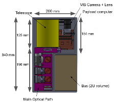
| Spacecraft | SEASALT (Satellite for Estimating Aquatic Salinity and Temperature) |
|---|---|
| Form factor | CubeSat |
| Units or mass | 3U |
| Status | not launched, expected in 2026 |
| Launcher | not launched |
| Organisation | MIT (Massachusetts Institute of Technology) |
| Institution | University |
| Entity type | Academic / Education |
| Nation | US |
| Operator | In-house? |
| Oneliner |
Explore the estimation of salinity in coastal environments using ocean color |
| Description |
Explore the estimation of salinity in coastal environments using ocean color. A SEASALT constellation would fill the coastal gap by providing coastal SSS observations with much higher spatial resolution (30m) and much shorter revisit times (less than 1 day) on a global scale. |
| Notes | |
| Sources | [1] [2] |
| Photo sources | [1] [2] |
Last modified: 2025-12-20

