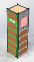
| Satellite name | FINCH (Field Imaging Nanosatellite for Crop residue Hyperspectral mapping) |
|---|---|
| Spacecraft type | CubeSat |
| Units or mass | 3U |
| Status | not launched, expected in 2026 |
| Launcher | Falcon 9 |
| Organization | University of Toronto |
| Institution | University |
| Entity type | Academic / Education |
| Headquarters | Canada |
| Oneliner |
Hyperspectral SWIR remote sensing CubeSat undertaking a crop residue mapping demo mission. |
| Description |
Hyperspectral SWIR remote sensing CubeSat undertaking a crop residue mapping demo mission. FINCH seeks to:
Use the atmospheric absorption features between 1600–1680 nm to measure CH4 column concentrations over GTA landfills. |
| Sources | [1] [2] [3] [4] [5] |
| Photo sources | [1] |
Last modified: 2025-12-21

